# AllTrails
## URL
## Description
AllTrails.com is a tool for discovering hiking, biking, and running trails worldwide, providing detailed trail maps, user reviews, and navigation support for outdoor enthusiasts.
AllTrails.com can be a valuable resource for open source researchers as it provides location data, user-generated content, and real-time information about various trails. Examples include tracking the movement patterns of individuals of public interest who share their activities publicly, analyzing geospatial data, and gathering insights from user reviews and pictures posted on the platform. It can also assist in understanding the terrain and accessibility of certain areas.
**Features**
*Map*
* **Current Location**: option to centre map at users location.
* **Zoom tool:** zoom in and out on the map.
* **Layers**:
* **Map Types:** AllTrails, Road, Satellite, USGS topo (US only), Terrain, World parks, OSM, OCM
* **Map Details:** Waypoints, Photos, Nearby trails, Distance markers, Heatmap, Weather, Air Quality, Light pollution, Pollen
* **3D view**
* **Compass North** - realign the map to compass north.
* **Search -** for locations including nearby.
* **Explore Filter** - Sort and filter by the following attributes distance away, activity, difficulty, length, suitability, More filters eg attractions, ratings, highest point, etc.
* **Elevation / Gradient -** Individual Trail maps include a line graph of elevations on route.
* **Print -** Individual Trail maps
* **Preview trails -** Individual Trail maps
*Explore*
* **Trails -** Curated AllTrails content and user-created Community trails
*Individual Trails*
* **Photos**
* **Directions**
* **Print**
* **Share**
* **Description**
* **Conditions:** weather forecast, expected ground conditions and mosquitos.
* **Reviews:** user reviews include the user profile, text and star rating.
* **Activities:** user activities in this area.
* **Completed:** list of users who have completed the trail.
* **Route FAQs**
*Community*
* **Local:** see public user activity nearby.
* **Following:** see activity from user's that you follow.
* **Engagement:** Like and Comment on posts.
* **Connect:** connect with other users.
*Profile - users' personal profile and where they have made public contributions that can be seen on other people's profiles.*
* **Favourites**
* **Photos**
* **Reviews:** reviews the user has made.
* **Activities**
* **Completed:** trails users have completed
* **Followers**
* **Following**
* **Stats**
* **Lists**
*User Profile*
* **Feed:** activities of people you follow.
* **Create Map:** create a custom trail.
* **Language**
* **Saved**
* **Settings** - location, Units (Imperial or metric), calorie counter info, link to Facebook, Google, Apple, Garmin
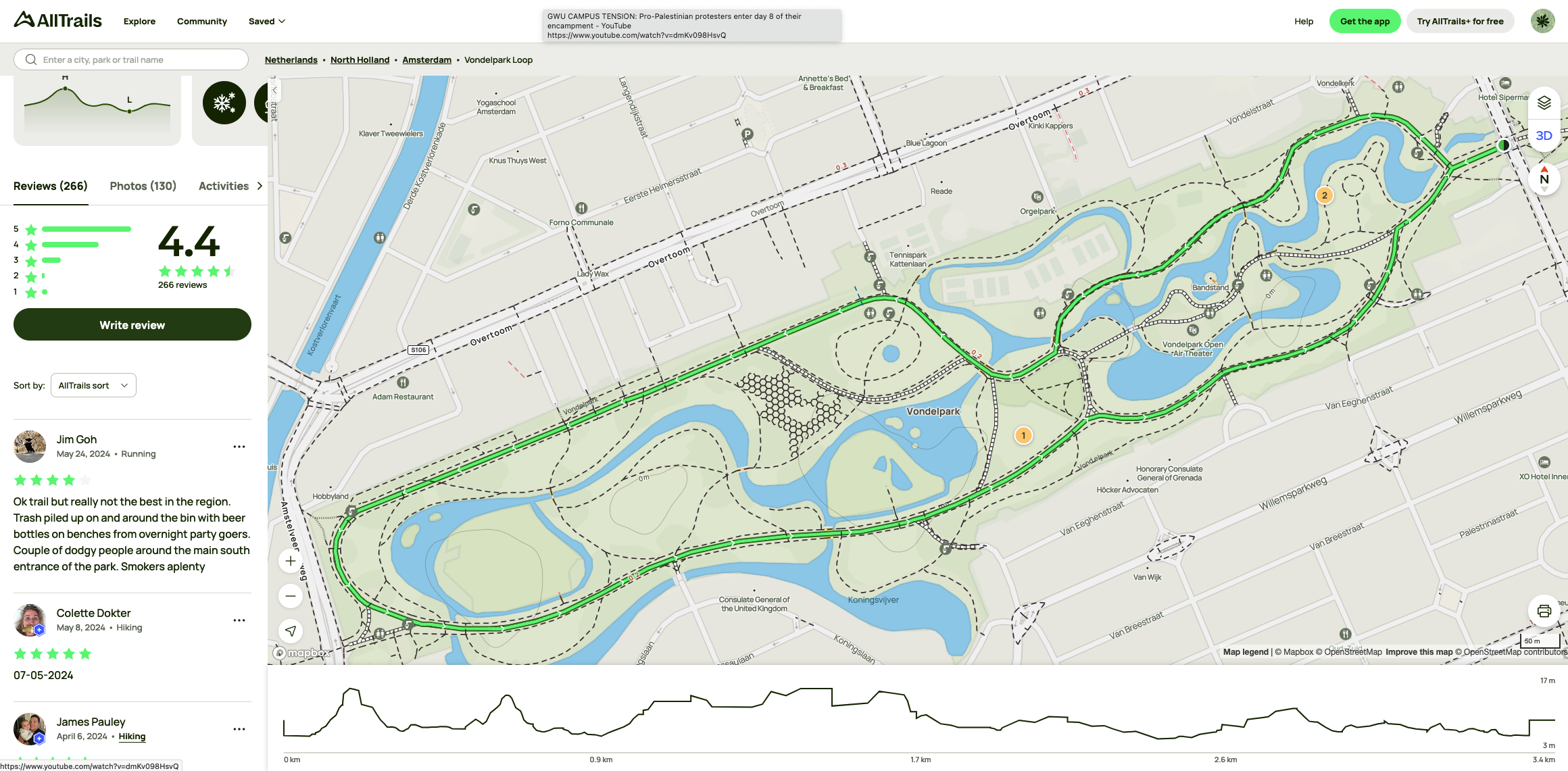
Example below shows search for Vondelpark Loop in Amsterdam:
Screenshotof Vondelpark Loop in Amsterdam
## Cost
* [ ] Free
* [x] Partially Free
* [ ] Paid
**Free Tier**
* Navigate on the trail
* Favorite trails
* Create lists
**Paid Tier**
* Download offline maps
* Get alerts for wrong turns
* Live share activities
* New Access 200+ Guides Know conditions before you go
* Preview 3D Flyovers
* Find trails by distance from you
* Unlock more map details
* Print maps for backup
* Give back with 1% for the Planet
## Level of difficulty
2
## Requirements
* **Web**: any modern web browser.
* **Mobile:** iOS and Android
* **Email address:** Email address for an account
## Limitations
* **Subscription Fees**: Some features require a paid subscription to access, see: [AllTrails+](https://www.alltrails.com/plus)
* **Offline Access**: Offline maps are only available to Pro members, see: [AllTrails+](https://www.alltrails.com/plus)
* **User-Generated Content**: Information can be inconsistent or outdated due to reliance on user reviews and submissions.
* **Coverage**: Some trails might not be covered or accurately mapped in less popular regions. There is no generalised documentation on this and gaps in coverage will be found as you use the app.
* **Accuracy**: AllTrails using crowd sourced data and has been criticised for accuracy issues see: [The Problem With AllTrails](https://adamthompsonphoto.com/blog/the-problem-with-alltrails) and [AllTrails.com Haters: The Problem isn’t the App, It’s Us](https://www.northeastmountainpeople.com/on-hiking-home/alltrailscom-haters-the-problem-isnt-the-app-its-us)
## Ethical Considerations
* **Privacy**: open source researchers should exercise responsibility when using All Trails data as not all users will be aware of the [default privacy settings](https://support.alltrails.com/hc/en-us/articles/15928750195604-What-are-the-default-privacy-settings-when-I-create-an-AllTrails-account).
* **Stalking:** All Trails provides information that can facilitate stalking behaviours. Open source researchers should be aware stalking is a prosecutable offence in most countries, for instance in the UK see sections 2, 2A, 4 and 4A of the [Protection from Harassment Act 1997](https://www.legislation.gov.uk/ukpga/1997/40/contents) (PHA 1997) and [section 42A (1) Criminal Justice and Police Act 2001](https://www.legislation.gov.uk/ukpga/2001/16/section/42A). [Section 32 Crime and Disorder Act 1998](https://www.legislation.gov.uk/ukpga/1998/37/section/32).
## Guides and articles
To effectively use AllTrails, especially for beginners or those looking to refine their skills, the following resources are highly recommended:
**Official Wiki**
*
**Tutorials and Articles**
* Cox, J. (2023) ‘AllTrails Data Exposes Precise Movements of Former Top Biden Official’, *Vice*, 8 March. Available at: (Accessed: 17 June 2024).
* *Getting Started with AllTrails+ Overview* (2023) *AllTrails Help*. Available at: (Accessed: 17 June 2024).
**Video Tutorials**
* *How to Use AllTrails 2022* (2022). Available at: (Accessed: 17 June 2024).
* *How To Use the AllTrails App (For Beginners)* (2022). Available at: (Accessed: 17 June 2024).
* *University of Connecticut - MediaSpace* (no date). Available at: (Accessed: 17 June 2024).
#### Developer Resources
*
**Community and Support**
*
## Tool provider
AllTrails, LLC - USA
## Advertising Trackers
* [x] This tool has not been checked for advertising trackers yet.
* [ ] This tool uses tracking cookies. Use with caution.
* [ ] This tool does not appear to use tracking cookies.
| Page maintainer |
| ------------------------------------ |
| Bellingcat Volunteer Team/Unassigned |
| |